![](/images/other/stat-length.png)
2022-06-01 Rando CVA Le Tholy Boucle Cascades du Tendon
holtzv
Benutzer GUIDE
![Länge](/images/other/stat-length.png)
Länge
24 km
![Maximale Höhe](https://static1.geolcdn.com/siteimages/upload/files/1508320355ic_sort_altitude_max_24dp.png)
Maximale Höhe
788 m
![Positive Höhendifferenz](https://static1.geolcdn.com/siteimages/upload/files/1508320355ic_sort_den_pos_24dp.png)
Positive Höhendifferenz
739 m
![Km-Effort](/images/other/stat-length.png)
Km-Effort
34 km
![Min. Höhe](https://static1.geolcdn.com/siteimages/upload/files/1508320355ic_sort_altitude_min_24dp.png)
Min. Höhe
471 m
![Negative Höhendifferenz](https://static1.geolcdn.com/siteimages/upload/files/1508320355ic_sort_den_neg_24dp.png)
Negative Höhendifferenz
731 m
![Boucle](https://static1.geolcdn.com/siteimages/upload/files/16400158638029165_repeat_loop_refresh_sync_direction_icon.png)
Boucle
Ja
Erstellungsdatum :
2022-06-01 09:03:49.634
Letzte Änderung :
2022-06-10 11:30:01.976
![Reiten](https://static1.geolcdn.com/sitytour/trail-icons/301.png)
5h16
Schwierigkeit : Schwierig
![Scannen Sie diesen QR-Code, um die Tour in der SityTrail-Anwendung zu öffnen](https://capi.geolives.com/qq0zvz2zws4bq2lad0pu/sitytour/trails/3266242/qr.png?size=200)
Kostenlosegpshiking-Anwendung
Über SityTrail
Tour Reiten von 24 km verfügbar auf Großer Osten, Vogesen, Le Tholy. Diese Tour wird von holtzv vorgeschlagen.
Beschreibung
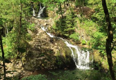
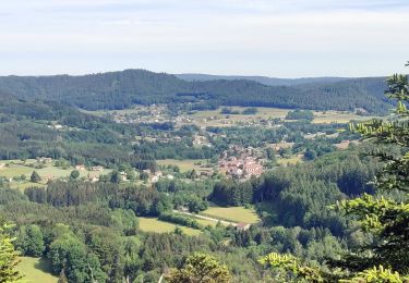
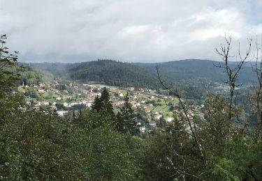
Boucle au départ d'Equi'Val au village le Tholy en passant par un joli sentier le long de la rivière Barba, le village de Rehaupal pour l'apéro, les Roches de la Moulure, et la petite et la grande cascades du Tendon
Ort
Land:
France
Region :
Großer Osten
Abteilung/Provinz :
Vogesen
Kommune :
Le Tholy
Standort:
Unknown
Gehen Sie:(Dec)
Gehen Sie:(UTM)
330912 ; 5328891 (32U) N.
Kommentare
Touren in der Umgebung
![Tour Wandern Tendon - Cascades de Tendon - Trou de l'Enfer - Roches de la Moulure - Photo](https://media.geolcdn.com/t/375/260/6cb30f79-01f0-4a87-b35f-5f5af3475353.jpg&format=jpg&maxdim=2)
![Wandern Wandern](https://static1.geolcdn.com/sitytour/trail-icons/101.png)
Cascades de Tendon - Trou de l'Enfer - Roches de la Moulure
Wandern
Medium
(4)
Tendon,
Großer Osten,
Vogesen,
France
![](/images/other/stat-length.png)
20 km | 28 km-effort
5h 33min
![](https://static1.geolcdn.com/siteimages/upload/files/16400158638029165_repeat_loop_refresh_sync_direction_icon.png)
Ja
![Reiten Reiten](https://static1.geolcdn.com/sitytour/trail-icons/301.png)
2022-06-03 Rando CVA Le Tholy Gerbamont
Reiten
Sehr schwierig
Le Tholy,
Großer Osten,
Vogesen,
France
![](/images/other/stat-length.png)
28 km | 41 km-effort
6h 25min
![](https://static1.geolcdn.com/siteimages/upload/files/16400158638029165_repeat_loop_refresh_sync_direction_icon.png)
Nein
![Tour Reiten Le Tholy - 2022-06-02 Rando CVA Le Tholy Tête des Cuveaux - Photo](https://media.geolcdn.com/t/375/260/655700ee-4545-4284-b9be-e2f2446a936f.jpg&format=jpg&maxdim=2)
![Reiten Reiten](https://static1.geolcdn.com/sitytour/trail-icons/301.png)
2022-06-02 Rando CVA Le Tholy Tête des Cuveaux
Reiten
Schwierig
Le Tholy,
Großer Osten,
Vogesen,
France
![](/images/other/stat-length.png)
28 km | 40 km-effort
5h 19min
![](https://static1.geolcdn.com/siteimages/upload/files/16400158638029165_repeat_loop_refresh_sync_direction_icon.png)
Ja
![Tour Wandern Le Tholy - tendon - Photo](https://media.geolcdn.com/t/375/260/ext.jpg?maxdim=2&url=https%3A%2F%2Fstatic1.geolcdn.com%2Fsiteimages%2Fupload%2Ffiles%2F1553511878bg_sport_marche.png)
![Wandern Wandern](https://static1.geolcdn.com/sitytour/trail-icons/101.png)
tendon
Wandern
Einfach
(4)
Le Tholy,
Großer Osten,
Vogesen,
France
![](/images/other/stat-length.png)
9,1 km | 12,9 km-effort
3h 1min
![](https://static1.geolcdn.com/siteimages/upload/files/16400158638029165_repeat_loop_refresh_sync_direction_icon.png)
Ja
![Tour Wandern Le Tholy - Sentier de la Roche Au Blaireau depuis le gîte - Photo](https://media.geolcdn.com/t/375/260/953f411c-aa19-4208-97f3-48d7a7911f9d.jpg&format=jpg&maxdim=2)
![Wandern Wandern](https://static1.geolcdn.com/sitytour/trail-icons/101.png)
Sentier de la Roche Au Blaireau depuis le gîte
Wandern
Medium
Le Tholy,
Großer Osten,
Vogesen,
France
![](/images/other/stat-length.png)
4,4 km | 6,5 km-effort
1h 25min
![](https://static1.geolcdn.com/siteimages/upload/files/16400158638029165_repeat_loop_refresh_sync_direction_icon.png)
Ja
![Tour Wandern Le Tholy - La grande cascade du Tendon au départ du Grand Caillou. - Photo](https://media.geolcdn.com/t/375/260/29f756ea-f122-4fe5-a807-1bae772526aa.jpg&format=jpg&maxdim=2)
![Wandern Wandern](https://static1.geolcdn.com/sitytour/trail-icons/101.png)
La grande cascade du Tendon au départ du Grand Caillou.
Wandern
Schwierig
Le Tholy,
Großer Osten,
Vogesen,
France
![](/images/other/stat-length.png)
9 km | 12,2 km-effort
2h 46min
![](https://static1.geolcdn.com/siteimages/upload/files/16400158638029165_repeat_loop_refresh_sync_direction_icon.png)
Ja
![Tour Wandern La Forge - La roche des corbeaux, La Forge - Photo](https://media.geolcdn.com/t/375/260/130216fa-767d-4902-bf97-0a8dff8eb2b3.jpg&format=jpg&maxdim=2)
![Wandern Wandern](https://static1.geolcdn.com/sitytour/trail-icons/101.png)
La roche des corbeaux, La Forge
Wandern
Medium
La Forge,
Großer Osten,
Vogesen,
France
![](/images/other/stat-length.png)
7,8 km | 11,2 km-effort
2h 33min
![](https://static1.geolcdn.com/siteimages/upload/files/16400158638029165_repeat_loop_refresh_sync_direction_icon.png)
Ja
![Tour Wandern Le Tholy - Le trou de l'enfer - Photo](https://media.geolcdn.com/t/375/260/b8b0e984-8b12-439a-8fed-764b95b3aaa2.jpg&format=jpg&maxdim=2)
![Wandern Wandern](https://static1.geolcdn.com/sitytour/trail-icons/101.png)
Le trou de l'enfer
Wandern
Medium
Le Tholy,
Großer Osten,
Vogesen,
France
![](/images/other/stat-length.png)
10,2 km | 14,2 km-effort
2h 48min
![](https://static1.geolcdn.com/siteimages/upload/files/16400158638029165_repeat_loop_refresh_sync_direction_icon.png)
Ja
![Tour Wandern Cleurie - Circuit Cleurie / ST Amé - le Fossard - Photo](https://media.geolcdn.com/t/375/260/357e72c1-9c3e-42c8-b377-9a755632ac33.jpg&format=jpg&maxdim=2)
![Wandern Wandern](https://static1.geolcdn.com/sitytour/trail-icons/101.png)
Circuit Cleurie / ST Amé - le Fossard
Wandern
Einfach
Cleurie,
Großer Osten,
Vogesen,
France
![](/images/other/stat-length.png)
14,1 km | 18,5 km-effort
3h 16min
![](https://static1.geolcdn.com/siteimages/upload/files/16400158638029165_repeat_loop_refresh_sync_direction_icon.png)
Ja